If you build or test drones, the site you lease near Bangalore matters for more than rent. Under the Drone Rules, 2021, a drone manufacturer can test its own drones on its own premises without the usual permissions, but only if those premises are in a green zone on the official Digital Sky airspace map. Inside the bands around the city's airfields, the same test flight needs permission first.
This guide is for drone makers, assemblers, R&D teams and drone-services firms choosing a factory, warehouse or test site around Bangalore. It explains the zones, shows where the airfields are, and groups the industrial corridors we track by how close they sit to them. It is a planning aid, not legal or regulatory advice. Zones change, and the live map is the only authority.
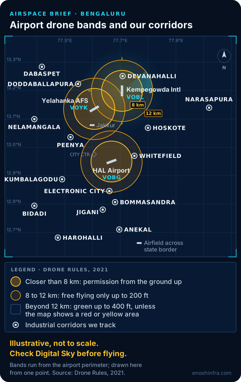
Airport drone bands and industrial corridors around Bangalore, illustrative, not to scale
Illustrative, not to scale. Check Digital Sky before flying.
Why the airspace map matters when you lease
For a drone company, a site's airspace zone decides whether you can test at home or must apply for permission every time.
Rule 42 of the Drone Rules, 2021 covers research, development and testing. It lets certain organisations, including drone manufacturers registered for GST, DPIIT-recognised startups and recognised R&D bodies, fly for testing without a type certificate, a unique identification number, prior permission or remote pilot certification. The condition is that the flights happen in a green zone, inside their own premises or in an open green-zone area under their control.
So two buildings with the same rent can be very different tenancies for a drone team. One lets you hover-test in your own yard. The other means a permission request, or a drive out of town, for every flight.
Even in a green zone, rule 21 requires the pilot to check Digital Sky for notices and restrictions before each operation. A site that is green today is not a promise for next month.
Green, yellow and red: the zones in plain terms
The airspace map splits India into three colours, and the airport distances are measured from the airport's perimeter, not its centre.
Green zone: airspace up to 400 ft (120 m) that is not marked red or yellow, plus airspace up to 200 ft in the band 8 to 12 km from the perimeter of an operational airport. No prior permission is needed.
Yellow zone: airspace above 400 ft in a green area, above 200 ft in the 8 to 12 km band, and from ground level up in the band 5 to 8 km from the perimeter. Flying here needs permission from the air traffic control authority for that airspace, which can be AAI, the Indian Air Force, the Navy or HAL.
Red zone: a no-drone zone. Flights need Central Government permission. Red zones can cover airports, defence and other specified installations wherever the government designates them.
Closer than 5 km to an airport: the 2021 release does not define this band separately. Treat it as needing permission, and read the live map.
These figures come from the Drone Rules, 2021 and the Ministry of Civil Aviation's airspace map release of September 2021, which cut the yellow zone around airports from 45 km to 12 km. In 2023 the government told Parliament that nearly 90 percent of India's airspace is green.
Two more rules matter for planning. Changes to the map take effect no sooner than seven days after they are published (rule 23). And a State Government, a Union Territory or the police can declare a temporary red zone for up to 96 hours at a time (rule 24).
A "green zone" industrial area is not a drone green zone
The two "green zones" are unrelated, and mixing them up is easy when you search for a site.
Industrial property in Karnataka is graded Green, Orange or Red by pollution category, which decides what processes a site can run. Our area pages use those labels. A Green category industrial area says nothing about the airspace above it, and a drone green zone says nothing about what you may manufacture below it. Check both. Our industrial zones guide explains the pollution categories.
The airfields that shape Bangalore's map
Four airfields set most of the airport bands around the city.
Kempegowda International Airport, north of the city, beside Devanahalli.
HAL Airport, in the east of the city.
Yelahanka Air Force Station, to the north, home of the Aero India show.
Jakkur aerodrome, a smaller airfield just south of Yelahanka.
Temporary restrictions come on top. During past Aero India shows at Yelahanka, the city police have issued orders barring drones across Bengaluru for the event, press reports show. VIP visits can bring short-notice red zones too. If your test schedule is tight, watch for these.
Our corridors against the airport bands
Grouped by straight-line distance from the four airfields, using the locations on our own area pages, the corridors fall into three groups. None is confirmed green by this guide. Check the exact plot on the live map.
Close to an airport: expect to need permission for most flying
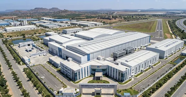
Devanahalli, beside Kempegowda International. The KIADB Aerospace Park is here: a strong place to build, a hard place to fly.
Hebbal, between Jakkur, Yelahanka and HAL.
Whitefield, east of HAL Airport.
Near the edge of a 12 km band: depends on the exact site
Electronic City and Bommasandra, south of HAL Airport.
Doddaballapura, north-west of Yelahanka.
Peenya, west of Jakkur and Yelahanka.
Hoskote, south-east of Kempegowda International.
Anekal, near an airfield across the state border.
Typically well clear of the airport bands
Nelamangala and Dabaspet, to the north-west on the Tumkur road.
Bidadi, Harohalli and Kumbalagodu, to the south-west.
Jigani, to the south.
Narasapura (also written Narsapura), to the east on the Kolar road. It has no page of its own yet; its range is in our rental rate index.
"Clear of the airport bands" is not the same as green. Red zones around other installations, temporary red zones and local rules can still apply, and a neighbouring landlord or a protected area nearby can make flying impractical even where the map allows it.
Split the factory from the test site
Many drone teams do not need to fly where they build, and keeping the two apart widens the choice.
A city-side corridor near your engineers and suppliers can hold assembly, electronics and stores. Flight testing then happens at an outer site you control in a green zone, or under permission elsewhere. If you want one site for both, look at the outer corridors first and ask for land or a building with an open yard. Our industrial land and build to suit page covers taking land or having a landlord build to your specification.
There is also a state option on the way. In September 2026 the Karnataka Government announced a drone testing facility at Jeedarahalli in Chintamani taluk, Chikkaballapura district, with segregated airspace for trials, press reports show. Check its status and access terms before you plan around it.
What to check in the building
A drone unit asks for a few things a standard shed may not have.
Battery storage and charging. Plan a separate area for charging and storing lithium batteries. The operating Fire NOC is yours to apply for, based on what you store and make, so tell the fire consultant about the batteries early.
Electronics benches. Flight controllers and payloads need ESD-safe work areas and clean, steady power with backup. Check the sanctioned load on the landlord's power letter.
Open space you control. If you plan to test on site, you need a yard or open land inside your boundary, not shared access.
The lease itself. If you will fly on the premises, ask for that use to be allowed in writing in the lease. On KIADB land, the landlord needs KIADB's written permission to sub-let to you.
Pollution category. Light assembly often fits Green or Orange, but composites, paint or battery work can change the category. See the industrial zones guide.
For general sheds and sizes across the city, see our industrial sheds and factories for rent page. If your work is closer to aerospace and defence, our aerospace and defence post covers that side of Devanahalli.
PLI, import rules and Karnataka policy
Three policies shape the business case, and each is worth checking at the source before you commit.
PLI for drones and drone components. The Ministry of Civil Aviation notified a Rs 120 crore production linked incentive on 30 September 2021, paid at 20 percent of value addition, for financial years 2022-23 to 2024-25. Press reports in 2026 describe a successor scheme. Check the ministry's site for what is open now.
Imports. Since February 2022, importing complete drones (built-up, semi or completely knocked down) has been prohibited, with exceptions for R&D, defence and security. Drone components remain free to import. Plan supply and stores around components.
Karnataka. The state cabinet approved a Karnataka Aerospace Policy 2026-31 in September 2026 that covers drones and encourages units outside Bengaluru, press reports show. Incentives can differ by location, so ask how your shortlisted corridors are treated.
A draft Civil Drone (Promotion and Regulation) Bill was published for consultation in September 2025. If it is passed, it would replace the Drone Rules, so recheck the rules before signing a long lease around a testing plan.
Where our work starts and stops
We find the buildings or land, have the documents checked by our partner advocate, negotiate the lease, and coordinate with the landlord through handover. For build to suit and land, our work ends when the agreement is signed. We do not advise on drone permissions or file applications on Digital Sky.
Enosh Infra has been an industrial property consultancy in Bangalore since 2019, handling requirements from 10,000 to 400,000+ sq ft.
Looking for a drone factory or test site near Bangalore? Tell us the size, whether you need to fly on site, and where your team and suppliers are, and we will come back with corridors and buildings that fit. Tell us your requirement